Land Prioritization Mapping for Protecting Drinking Water Quality
Conserving land to protect drinking water
**This project was updated in 2025 to include the entirety of the states in which the basin sits—the District of Columbia, Maryland, Pennsylvania, Virginia, and West Virginia. The new project can be found on the Interstate Commission on the Potomac River Basin’s website, Land Prioritization Mapping to Protect Drinking Water Quality (2025 Update).***
It is no secret that how we use our land has an impact on drinking water. Preserving and conserving specific parcels of land could protect the source of drinking water for people downstream.
The Land Prioritization Mapping for Protecting Drinking Water Quality was developed through funding from the U.S. Endowment for Forestry and Communities and eight DWSPP member water suppliers. The collaboration among Berkeley County Public Service District, DC Water, Fairfax Water, Frederick County, Loudoun Water, Town of Leesburg, Washington Aqueduct, WSSC Water, and ICPRB explored the following question:
Which parcels of land in the Potomac River basin are the most beneficial to drinking water?
Objective Statement
The stakeholder-developed objective statement was to rank parcels of land to protect drinking water quality and their potential to degrade long-term water quality.
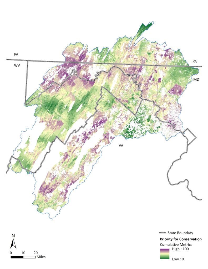
The Land Prioritization Mapping Project aims to assist land conservation organizations in prioritizing specific parcels of land to obtain the most drinking water quality benefits. The project area encompassed the non-tidal Potomac basin above the DC metro drinking water supply intakes. Within the study area, agricultural and forested lands, as well as riparian areas protected by county ordinance, were considered “opportunity areas” for prioritization. Land parcels were prioritized using seven metrics developed through a collaboration among the eight drinking water suppliers to rank land parcels to protect drinking water quality.
Products
The Interstate Commission on the Potomac River Basin completed the technical work. The analysis indicates that there are a total of 621 parcels comprising 3,737 acres of high-priority land in the study area. Download the flyer or the technical memo to get more information on these parcels. An interactive online map allows you to search for specific locations. For more detailed information on the parcels, a GIS-layer is available by contacting ICPRB.

Priorities for land conservation from a drinking water source protection perspective at the parcel scale in the Potomac basin. Higher-priority parcels are shown in purple. Lower-priority parcels are shown in green.
- Land Prioritization Project Flyer
- Land Prioritization Project Technical Memo
- Geodatabase GIS Mapping file is available by contacting ICPRB
Plan in Action
Presentations
Please contact ICPRB for more information on the project. The project has been presented on the following occasions:
- Potomac River Basin Drinking Water Source Protection Partnership on November 4, 2020
- Heidi Moltz gave the following presentation at the virtual ICPRB Business Meeting, December 1, 2020:
ICPRB Adopts Land Conservation Policy
At the Business Meeting of the Interstate Commission on the Potomac River Basin on March 2, 2021, the Commissioners adopted the following Land Conservation Policy:
The Interstate Commission on the Potomac Basin hereby adopts the criteria for identifying high-priority land parcels and the resultant rankings of specific parcels, as spelled out in the report of the Land Prioritization Project of the Drinking Water Source Protection Partnership as a Land Conservation Policy. The Commission urges the voluntary conservation of those specific parcels that have been identified in the Land Prioritization Project as important for the preservation of drinking water supplies in the Potomac River Basin.*
*DISCLAIMER: The Interstate Commission on the Potomac River Basin (ICPRB) does not provide tax, legal or accounting advice. The ICPRB’s Land Conservation Policy and related materials has been prepared for informational purposes only, and is not intended to provide, and should not be relied on for, tax, legal or accounting advice. You should consult your own tax, legal and accounting advisors before engaging in any transaction involving ICPRB’s Land Conservation Policy.
Project Sponsors
- U.S. Endowment for Forestry and Communities
- Berkeley County Public Service Water District
- DC Water
- Fairfax Water
- Frederick County (MD) Division of Water and Sewer Utilities
- Loudoun Water
- Town of Leesburg (VA) Department of Utilities
- Washington Aqueduct
- Washington Suburban Sanitary Commission (WSSC Water)

Contact the Interstate Commission on the Potomac River Basin for questions or for more information.
Interactive Online Map of the Priority Parcels
Click here to open the map in your internet browser.

